Do you love to travel? Alternatively, maybe you prefer to armchair travel by watching travel shows on television. Either way, you probably know that our Earth has some pretty spectacular and some downright strange places. Some are worth visiting, but some are probably best enjoyed from a distance — from a very, very far distance. Like the lakes in Africa that explode or the forest in Romania sees more than its share of paranormal activity. Nevertheless, even if they are strange, they are also fascinating places worth visiting if you like the thrills.
However, some places, like a bay full of stars in Puerto Rico or the floating mountains of China, should be added to your travel bucket list. In this world full of wonder, it’s truly magical learning about these places and how bizarre some are. Join us while we do mental travels to some of the areas that you might never think existed. Experiencing these places will make you realize all over again what a truly magical, breathtaking planet we live on. So sit back, grab some warm popcorn, and join us while we show you these incredible places.
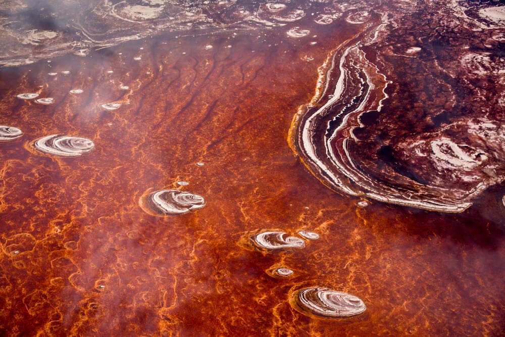
A Lake In Africa Literally Petrifies Dead Animals
Lake Natron might be the strangest place on Earth. It is located in Africa and is so high in alkaline elements that it appears to be red. However, that’s not the only thing about it that’s strange. It is known as the “Petrifying Lake” because of what it does to animals that die in it. Their bodies turn into mummies due to the high sodium bicarbonate, aka baking soda, present in the water. They first calcify, meaning that they turn into statues or petrify, so it weirdly preserves the bodies. The lake is petrifying!
This lake’s water temperature is extremely high. It can go up to 140 degrees Fahrenheit or 60 degrees Celsius. Nonetheless, this lake is the home of some type of endemic algae, birds, and invertebrates. Some fish can also survive even with the high levels of salt the lake has. That is also the only regular place in East Africa where less than 2.5 million flamingoes live whose status is “near threaten” because they depend on this one location for Spirulina, blue-green algae their favorite food. It is also their breeding area since it is an excellent barrier for predators trying to get into their nest.
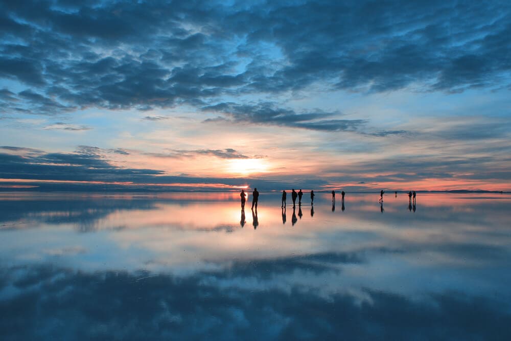
The World’s Largest Salt Pan Is Also The World’s Largest Natural Mirror
Salar de Uyuni, located in Bolivia’s South American country in the Daniel Campos Providence in Potosi, is the world’s largest salt flat. It covers over 4000 square miles and is essentially a desert made entirely of salt. It is dotted with lakes, and underneath are massive, salty reservoirs. The Salar was formed because of the transformations of various prehistoric lakes that were closed together. It was a few layers of salt crust, which has a flatness. This means that the entire salt flat, which is the largest in the world, is also the world’s most enormous mirror.
It also contains 70% of the world’s lithium reserves, as the briny waters are loaded with lithium. When it rains, a thin layer of dead calm water will transform the whole flat into the world’s most enormous mirror, measuring 80 miles or 129 kilometers across. In the middle of the Salar, there’s an island called Incahuasi, which is 60 acres and has a gigantic cactus in the middle. This place was used as a filming location for movies like Star Wars: The Last Jedi, The Unseen, Salt and Fire, and The Fall. The site is breathtaking to visit.

The Fetish Market In Togo Has All Kinds Of Superstitious Paraphernalia
The Akodowessa Fetish Market or Marche des Feticheurs is located in Lome, the capital city of the West African country of Togo. Over half of the local population practices indigenous beliefs, often connected to what many would see as magic and superstition. This place is the World’s largest voodoo market, with tons of bizarre and macabre things for you to buy. Some of the fetish market items are skulls, monkey heads, skins, dead birds, crocodiles, and any other dead animal they can find locally. Furthermore, you can get a voodoo doll for just $20, what a deal!
Voodoo is a very long tradition in Togo that goes back centuries ago. Slaves from Africa brought some traditions like Yoruba gods to areas like the Caribbean and South America. Because of it, thousands of people from all over the world visit the market every year. So if you need any paraphernalia for, say, a voodoo ritual, or you need an animal skull to make a magic potion for your enemies, go to the Akodowessa Fetish Market. Locals travel there to buy the things that they need for their spiritual practices.

Mexico Has A Macabre Island Full Of Little Dolls
The Island of Dolls is located in the Mexican province of Xochimilco. For a few decades, this island has been filled with a sad story and mystery, which has brought people worldwide to visit the place every year. According to the local legend, a young woman swimming in the canals surrounding the island became caught in some lilies and sadly drowned. After her body was recovered, dolls began washing to the island. Don Julian Santana was the island’s caretaker and became terrified as the toys washed ashore. As they kept appearing, Don Julian decided to hang them in trees as a tribute to the little girl he found drown in the same canal.
He believes that every doll that appears ashore is pieces of this girl’s soul trying to find her way home. Locals in the area said they had seen some mysterious things happen on the island, like seeing the dolls move their heads and arms or even opening their eyes. There are even witnesses claiming they had heard the dolls whispering to each other at night, and sometimes they lure people in boats to come to the island. In 2001, Don Julian was found drowned in the same spot the girl he saw was 50 years ago. Since then, the place has become even more popular with fans of the macabre and creepy things.
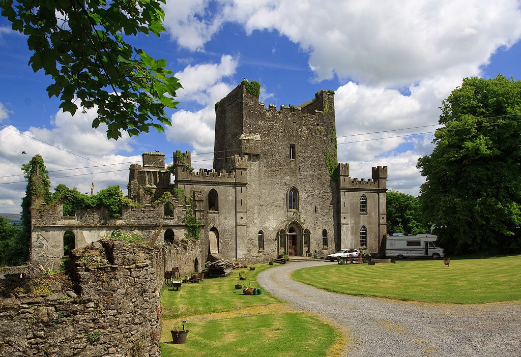
A Paranormal Force Patrols A Haunted Castle In Ireland
Leap Castle sits on a site occupied at least 500 CE. People describe it as the most haunted castle in the world. The building is on top of an ancient Druid torture pit. Legend says that a priest was slaughtered there while performing a mass. Now it is known as the “bloody chapel.” The priest was one of many people slain inside the castle that reportedly continue to haunt it today. A red lady wielding a knife is said to patrol the hallways, along with a mysterious force known as “the elemental.”
It is believed the castle was built between the 15th to the late 15th century. There is evidence that it was constructed in the same place as another structure believed to be for religious ceremonies. Since then, it has been occupied by different people between wars, plagues, and confrontations. There’s an area of the castle called “Bloody Chapel” where a man fatally wounded his brother. He died in front of his family and is believed to be one of the ghosts that habit the place. The castle has been featured on many paranormal investigation shows and is a favorite site for ghost-hunting enthusiasts.
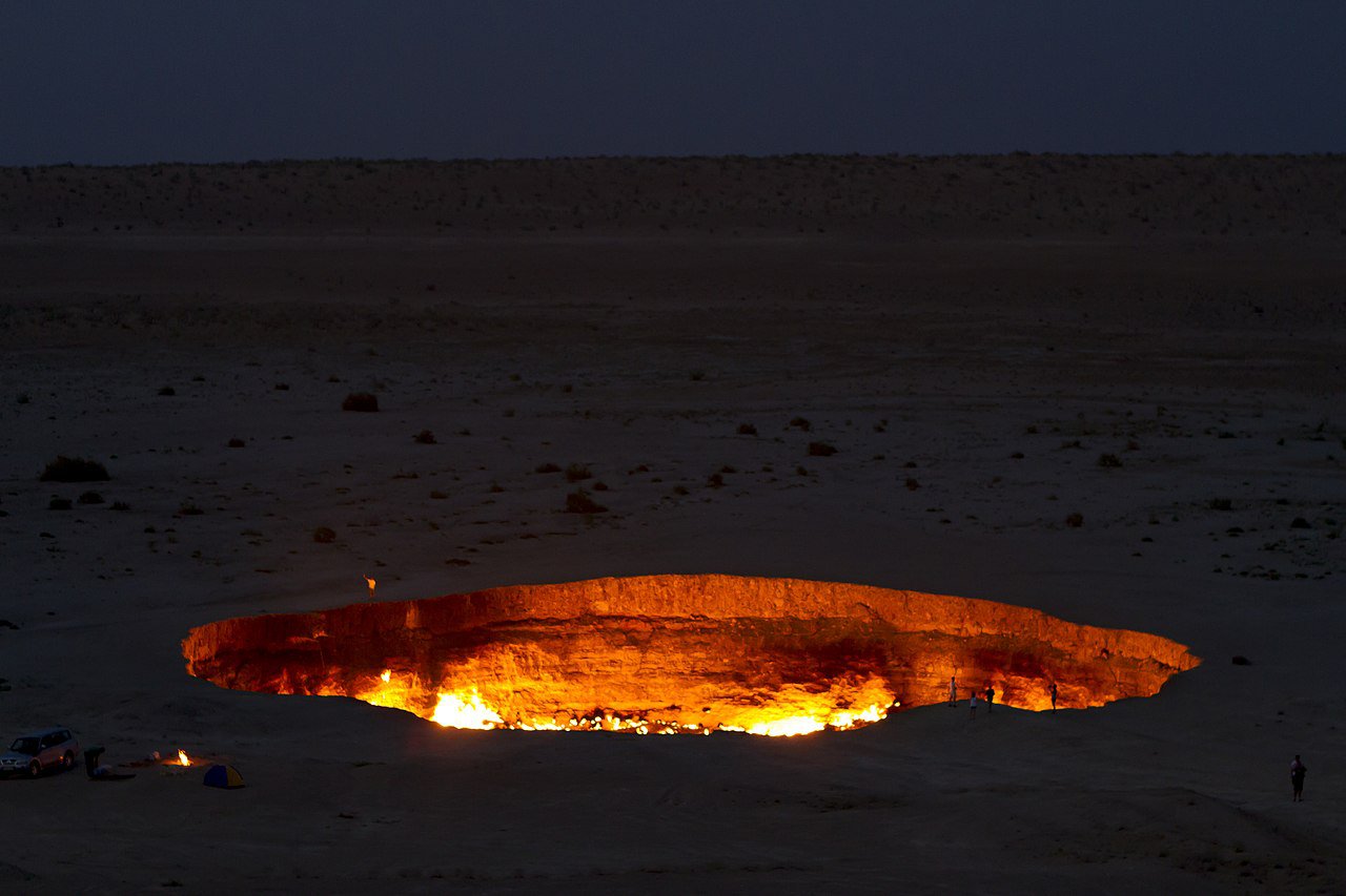
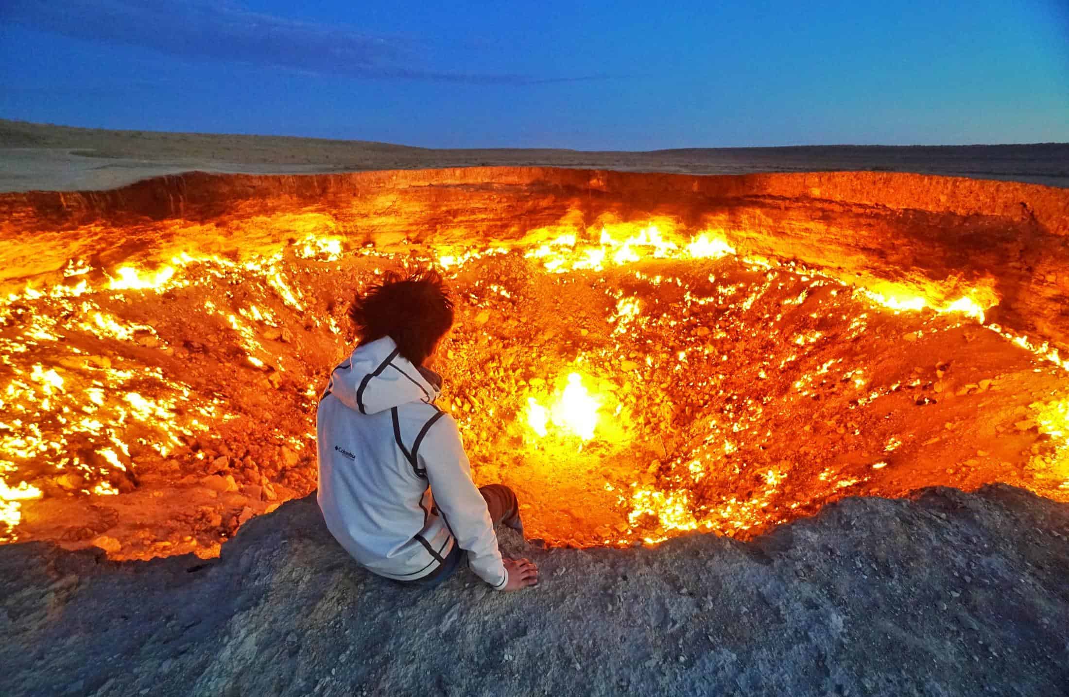
The Door To Hell Has Been Burning For Nearly Five Decades
The Darvaza gas crater is a site in Turkmenistan containing a natural gas field that collapsed into the ground while searching for oil fields. A team of Scientists accidentally started drilling on top of a pocket of natural gas, which couldn’t support the weight of the equipment collapsing in various places creating several open craters around the area and destroying all their gear. Soviet geologists set it on fire in 1971 to prevent methane from leaking into the atmosphere and damage the fauna around the already dying area. It has been burning ever since.
The largest of all the craters measures around 230 feet across and 65 feet deep. Scientists didn’t exactly know how much natural gas was in the cavity when they lit it on fire, so what they thought would take a few weeks to burn down has taken 50 years and is still going strong. The site is in the middle of the desert in a remote Central Asian country, so it isn’t precisely accessible or in many tour guides. However, the Turkmenistan government recognizes that the Door to Hell, as the Darvaza gas crater is popularly known, can bring tourists.

Romania Has Its Own “Bermuda Triangle”
Ever since Bram Stoker set his classic vampire Dracula as being from a region in Romania known as Transylvania, the country has developed a reputation for being a supernatural place, if not otherworldly, encounters. Cluj-Napoca, Romania, is the home of Hoia Baciu forest, a place filled with mystery and creepiness, known as the world’s most haunted forest. Inside this haunting forest, there’s an area called “The Clearing,” which is considered the creepiest place in Hoia Baciu, with investigators and scientists alike visiting the site to figure out why this area attracts so many people every year, including Romanian witches.
It is reportedly the scene of a high level of paranormal activity, including ghost sightings, faces in photographs that were not present when the photo was taken, and even UFO sightings. Many people have gone missing in the woods. People who visit often report feeling like they are being watched or are suddenly overcome with anxiety and even nausea. There are even reports of electronics devices having odd issues, seeing “ectoplasm” by daring joggers and shadow figures between the trees. Brave tourists and scientists alike find exciting is the misshapen trees in the area. Some have grown in zig-zag patterns or spirals with no scientific explanation, but believers think they are portals to other dimensions.
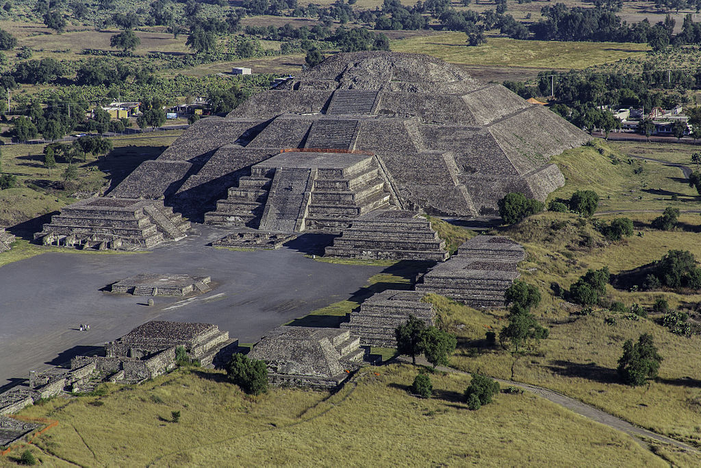
An Ancient City In Mexico Has An “Avenue Of The Dead”
Teotihuacan, located 30 miles or 50 kilometers from present-day Mexico City, was the home of a thriving culture that mysteriously vanished in about 600 CE. For some unknown reason, the civilization declined, and the city was uninhabited until the Aztecs rediscovered it. What is known is that it was built by hand over a thousand years before the Aztecs arrived in Central Mexico. According to George Cowgill, an Archeologist from Arizona State University, the mysterious city is 8 square miles with a population of a hundred thousand, and it was considered the largest city in the Western Hemisphere before the 1400s.
The Aztecs named the site Teotihuacan, which means “the place where the gods were formed.” However, they don’t know where it originally came from or who its builders were. The mysterious site has a macabre Avenue of the Dead, a pyramid-lined street that probably houses ancient rulers’ bodies. Interestingly, there’s evidence that this city has various cultures combined, like Maya, Zapotec, and Mixtec. All we know is that the mystery of this city brings around 4 million visitors every year to admire the secrets of the pyramid of the sun.

Nessie’s Home Is In The Scottish Highlands
Nessie, a nickname for the Loch Ness monster, supposedly lives in the incredibly deep waters of Loch Ness, the deepest Lake in Scotland. Loch Ness is located near the city of Inverness, way up in the Scottish Highlands. Rumors of a monster living in the waters began getting popular in the 1930s, but the stories have been around since ancient times. There are stone carvings of a mysterious beast with massive flippers made by the Picts, a group of Celtic-speaking folk who used to live in the area. Over centuries, the monster’s extraordinary stories have been roaming the area, but when a couple reported a monster crossing their car’s path in 1933, the Nessie legend became stronger.
Plenty of fantastical stories have been invented about the Loch Ness monster. In 1934, the iconic picture of a beast with a small head and long neck was photographed by English Physician Robert Kenneth Wilson. He brought international attention and even more tourists to visit. People come to see the famous location every day in the hopes of catching a glimpse of Nessie. Some theories suggest that Nessie is an ancient species that survived the mass extinction that killed off the dinosaurs, while others thoroughly believe the whole story is a hoax.
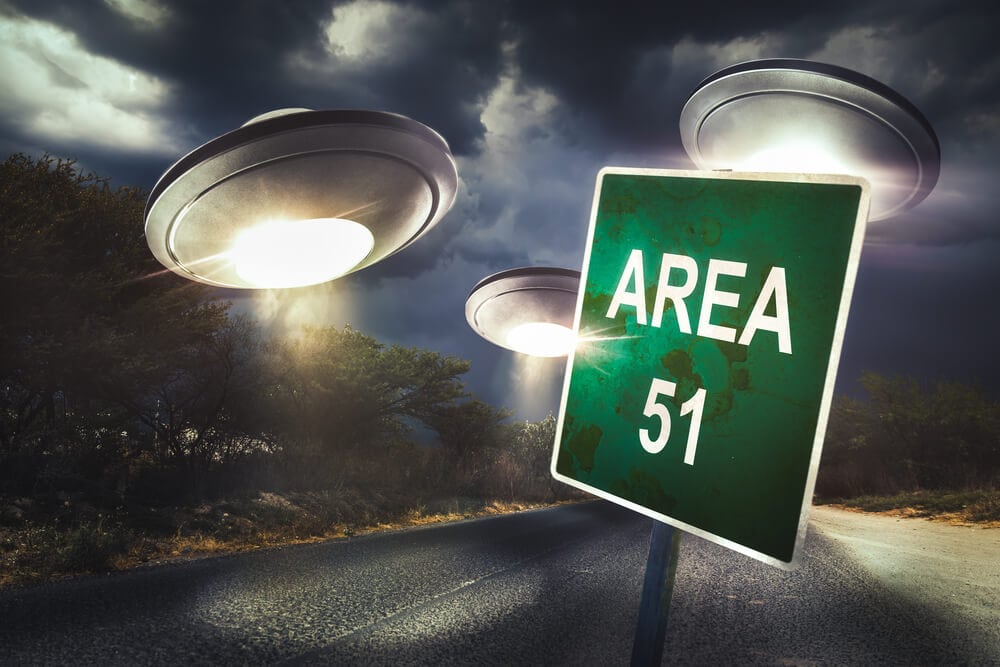
Area 51 Is A Real Site In Nevada
Area 51 is the name of a military base situated about 80 miles from Las Vegas, the biggest city in Nevada. The facility, which is the United States Air Force Airport, is believed to be used for testing experimental aircraft and weapons. Nevertheless, more than that, it has long been purported to be the secret location where government officials store aliens’ bodies and spacecraft. During the Cold War, the base was built between the United States and the Soviet Union. It was supposed to create and develop aircraft like the U-2 and the SR-71 Blackbird. Even if most people knew about Area 51 since the 50s, it wasn’t until 2013 that the CIA officially acknowledged it.
Most of the alien theories have been thoroughly debunked, and military bases are, by necessity, shrouded in secrecy. However, that doesn’t stop conspiracy theorists from demanding answers from the United States government and continuing to spread rumors about the otherworldly beings that are kept in isolation at Area 51. It also doesn’t stop Nevada authorities from capitalizing on the tourist dollars. Before you go “Storm Area 51”, it’s essential to know that this base is not open for tourism, but the city close by have made it a stop destination for anyone who loves to have a close encounter of the first kind.

Underground Parisian Streets Are Littered With Bones
Paris has been around for a long time, and many people have died within its limits over the centuries. Ancient graveyards became so full of bodies that city workers moved skeletons from anonymous pits into the catacombs that crisscross the city’s underground in the eighteenth and nineteenth centuries. In total, there’s more than 6 million human remains in the underground catacombs. The city started the process after an incident in 1774 where basement walls in Saint Innocents Cemetery collapsed, bringing an urge of urgency to find a new home for the dead.
The catacombs are situated in a small part of a tunnel network built to consolidate Paris’ ancient stone quarries. The ossuary was mostly forgotten until it became a fad to place concerts and private events in the 19th century. City officials recognized the potential that the underground catacombs had for drawing in more tourists (and more money). They arranged the anonymous skeletons into the arrangements that can be seen today, methods that are quite macabre and disturbing. In 2013, they became part of the Paris Museums managed by Paris Musées, which is the same institution that manages the archaeological crypts of Notre-Dame.
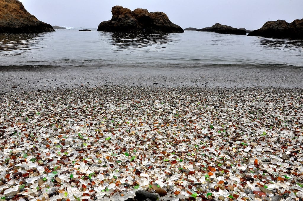
Trash Composes An Entire Beach
We have been polluting the oceans with our garbage for a long time, more so in recent years. In 1906, the Fort Bragg residents decided to make the beach behind the Union Lumber Company into an official water dumpsite. Residents will throw anything from appliances, vehicles, and lots of glass. It stopped being an active dumpsite until 1967. By then, people sold most of the metal trash, leaving the biodegradable waste and glass. The pounding waves of the area kept breaking down the glass, and with the help of the sand, it created smooth, small, colored pieces of glass that look like jewelry.
The beach gets thousands of visitors every year. It means that people tend to take a couple of pebbles as souvenirs home. These actions have become problematic for Glass beach. Thus, the activity is now illegal. Most of the glass is disappearing between the crashing waves and tourists, but there’s still hope for it. A few movements are trying to preserve this beach and researching how the glass has affected the area’s wildlife. There are several endangered and protected plants that only live in the area, including hybrid Menzies wallflower.
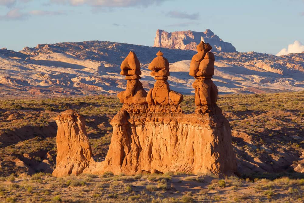
Strange Goblin-Like Structures Occupy Goblin Valley State Park
In Utah, 216 miles southeast of the capital city, Salt Lake City, is a remote valley full of giant sandstone pinnacles. The wind has eroded them to form bizarre formations called hoodoos, but the locals and tourists think they look like goblins. Hence the name Goblin Valley State Park. These mushroom-shaped rock formations can be several feet tall, some being the largest occurrences of hoodoos in the world. The area is relatively small, comparing it to the rest of the park, as it is only a mile or two across. There’s a lot of art hidden in the area that is great to look for.
Experts believe the Native American cultures like Fremont, Ute, and Paiute are responsible for the pictographs and petroglyph panels in the park. Cowboys discovered the secluded area in the 1920s when they were looking for cattle. The place was also known as the Mushroom Valley but later changed to the name we know today. Though getting there may take some time, visitors can easily hike through the area in a day. There are plenty of marked trails to make hiking more manageable. Just make sure to bring water, as it is a desert.
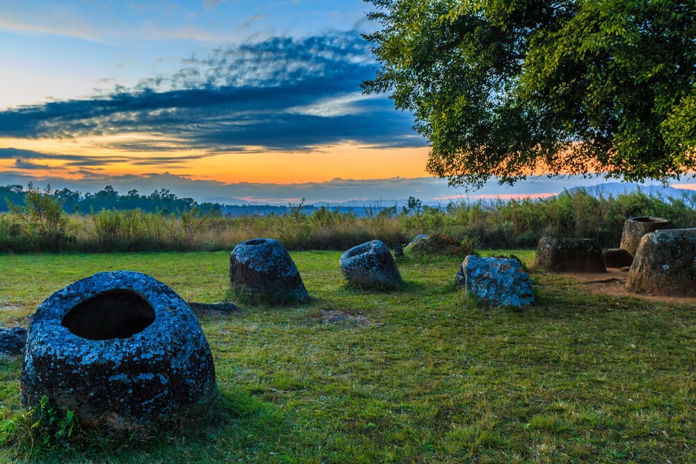
Giant Megalithic Jars Litter a Site In Laos
Laos is a country in Southeast Asia. The United States sent massive aerial bombardments over the country during the 1960s. People are finally clearing some of these areas. If you visit the site, you will be impressed. Nevertheless, there are still more than 90 areas in Xiangkhoang province with these mysterious jars arranged in hundreds of hundreds. The jars’ sizes vary, from 1 meter to 3 meters, and all made from rock, so it’s a fascinating cluster in every area. Some sites can have over 400 stone jars. Most are not decorated, except one which has a “Frogman.”
The “Frogman,” as some people call it, is carved on the jar’s exterior, and it has a slight resemblance to a rock painting made at Huashan in Guangxi, China. The carvings and paint are believed to be dated around 500BC to 200CE. The Plain of Jars is one such location. It is home to giant jars embedded into the Earth, which were presumably made for ancient funeral ceremonies. However, the local people have a different explanation, as legend explains that giants used them to make rice wine.
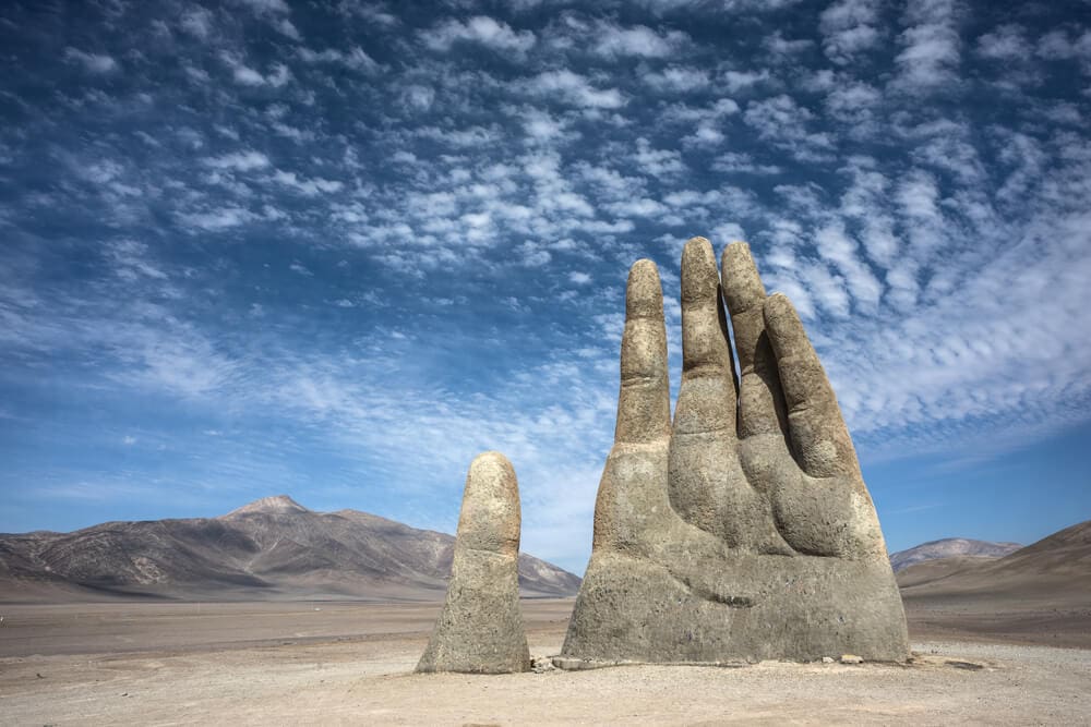
A Desert In Chile Has A Hand Rising Out Of The Sand
Modern art is often known to be perplexing and attempting to communicate something that only the artist is aware of. Sometimes we get too analytical, and maybe the significance of some pieces might not be that complicated. However, a sculptor in Chile, Mario Irarrazabal, created a massive hand that rises out of the sand in Chile’s Atacama desert that will leave you in awe. The hand supposedly depicts human suffering, a theme that is not difficult to grasp when one looks at it. Many of the works are unnerving and communicate feelings of loneliness, isolation, and desolation.
This hand can be found 46 miles outside of the city of Antofagasta; its remote location accentuates the theme that the artist is attempting to convey. He spent more than 25 years sculpting the hand, and the city of Antofagasta unveiled the result in March of 1992. The big hand is made out of concrete over an iron frame, and it’s taller than an NFL goalpost. “La Mano del Desierto” or “The Hand of the Desert” is a waving hand for many travelers that pass thru Chile’s Route 5. It is a good reminder that even when we think we’re alone, there’s someone there to bring us a hand.

An Island In Yemen Has The World’s Only Dragon-Blood Trees
Socotra Island is off the coast of Yemen, between Guardafui Channel and the Arabian Sea, the poorest country in the Middle East and one that has been decimated by years of war. The place is mostly isolated. Only a few thousand people live there. However, in contrast to the devastating mainland, Socotra Island has some of the rarest wildlife and plant life globally, including the world’s only dragon-blood trees. Some people have described the place as the “most alien-looking place on Earth,” with one-third of the plant life being endemic, it almost feels like you’re on another planet, and soon enough, aliens will come to rescue you.
Yes, dragon-blood trees are a real thing. They are part of the over 700 species of endemic plants found in Socotra. These are plants only found in a specific geographical location. The islander’s use the umbrella-shaped trees for paint and varnish. These trees are actually evergreens. However, their resin is known as dragon’s blood because of its red sap. The island also has the bulbous bottle tree and others not native anywhere else in the world. There’s a lot of rich flora and fauna in one place. In turn, the United Nations Educational, Scientific and Cultural Organization (UNESCO) recognized the location as a World Natural heritage.
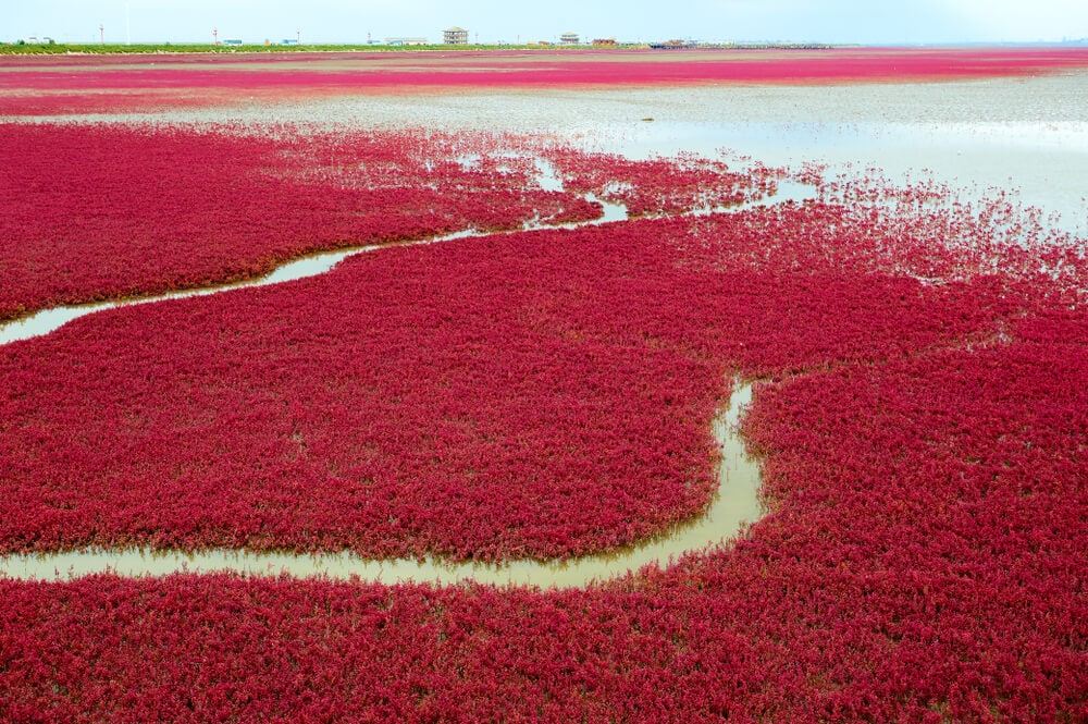
Red Algae Covers One Beach In China
If sand is the first thing that comes to mind when you think of the beach, you need to know about this remarkable place in China. Sueda salsa is a red alga that covers a beach in China’s Panjin province so that it grows a bright, fiery red with no view of the sand every fall. The algae start growing around April or May, looking like normal green algae until the end of the year where it becomes a sight to be seen. It makes the view of that beach like it belong on another planet.
As the site is known, Red Beach is a tidal wetland and reed marsh, and it is the largest in the world. It is home to over 250 different kinds of birds, like the Crown Cranes and Black Beaked Gulls, 400 types of animals, and to protect the hundreds of wildlife types there, most of the beach is inaccessible to the public. However, there are boardwalks over a small part of the beach. That way, people can visit to enjoy the view without damaging the splendor of the beach. Seeing that place in real life must feel like out of this world.
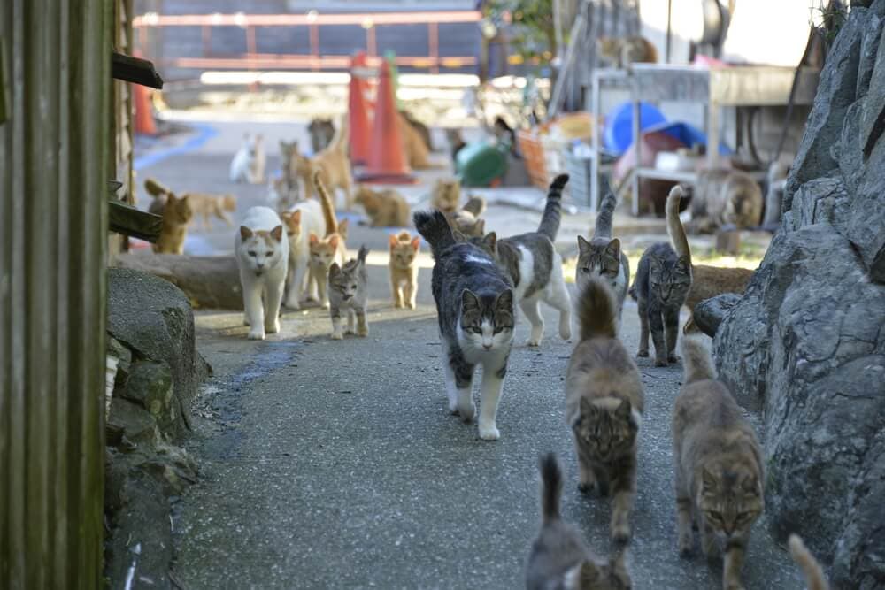
Japan Has A “Cat Island”
Cat lovers, rejoice. Aoshima, referred to as “Cat Island” by visitors and locals, is an island in the Japanese archipelago that felines have conquered that they outnumber humans, six to one. You will get a warm welcome as soon as you get out of the boat with hundreds of cats purring around the harbor. Since this island is the home to a fishing village, it became a haven for the cats that happily fed any fish they could find. They tend to find shelter anywhere they can, mostly in old buildings. Sometimes, a tourist will adopt one.
Felines were initially brought to the island to kill mice, spreading so rapidly that they were wreaking havoc on the island. Since there are few residents on Aoshima, most of the cats do not need to be neutered or spayed apart from some fishing villages. They reproduced like wildfire and now vastly outnumber humans. However, think twice before visiting because the vast number of cat-loving tourists who visit Aoshima has been putting stress on the island’s resources. The small population of residents had lowered to only 6. Cats were mostly neutered, so they kept reproducing, and they are still as friendly as ever.

Argentina Has Over 3000 Square Miles Of Salt Flats
Salinas Grandes is a vast swathe of land in the northwest of Argentina that appears to be covered in snow year-round. However, the white stuff covering the ground isn’t snow. It’s salt. The salt is much more concentrated than what you put on your food, but it is possible to use it in cooking. The white landscape, not only is breathtaking, but it can play tricks on you! The vast, empty backdrop can play with your mind and mess with your perspective, so for photo enthusiasts, this is an excellent opportunity to have fun with it.
The Salinas Grandes formed from a prehistoric saltwater lake that evaporated, leaving behind all of the salt. The high quantities of sodium and potassium are being used to push the industry even further. Moreover, 300,000 hectares are being used to explore Lithium brine underneath the salt. Very little can live out there, even in the way of plant life. Thus, animals tend to stay mostly away from the area. There aren’t even many humans out there, as only some specially adapted microbes can thrive in this extreme environment.
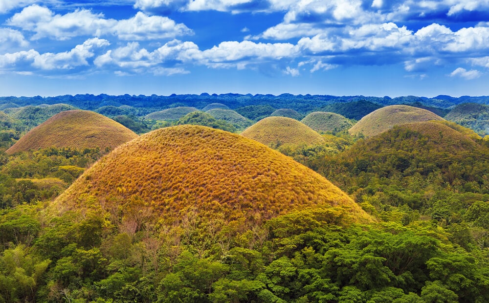
The Philippines Have Giant Mounds Of Chocolate
Not really, but the Chocolate Hills sure do look like real chocolate, especially during the dry months, when there is no vegetation growing on them. They are located on the island of Bohol and are one of the most-visited places in the Philippines. Most of the hills’ vegetation is mostly a few different grass-like Imperata cylindrica and several ferns. The space between it is used to grow rice and other crops. When the dry season comes, it looks like big chocolate kisses in a breathtaking landscape. because of these hills’ shape
The hills covered 31 square miles of the island and were probably formed by ancient coral deposits, which were left behind by an ancient ocean that once covered the area. Over 1700 hills spread for nearly 50 square kilometers or 20 square miles, causing the landscape to look like a seemingly endless bed of chocolate springing out of the Earth. Two hills are being used for tourist resorts, which are said to have the best view of the hills you can get, and it has more information about how these beautiful hills were formed.
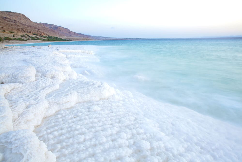
The Dead Sea Is The Lowest Place On Earth
You may know of the Dead Sea as the saltiest body of water on Earth, as only microbes can live in its waters due to the excessively high salt content. It is also the lowest place on Earth, as the sea’s surface begins 1300 feet below sea level! For centuries, the Dead Sea has attracted visitors for different reasons, mostly for health because of all the products that can be made using the high sodium of the water, which is 9.6 times as salty as the ocean. Egyptians even used it for mummification.
The sea is called “dead” because its high sodium prevents any macroscopic aquatic organisms from living, like fish or aquatic plants. There are only a few bacteria and fungi that can survive this environment. When it rains, the salt content can drop from the usual 35% to lower than 30%. The area, which is on the border of Jordan and the West Bank, has scorching temperatures in the summer and is extremely dry. Many people visit the Dead Sea during the fall and spring when the weather can be quite pleasant.
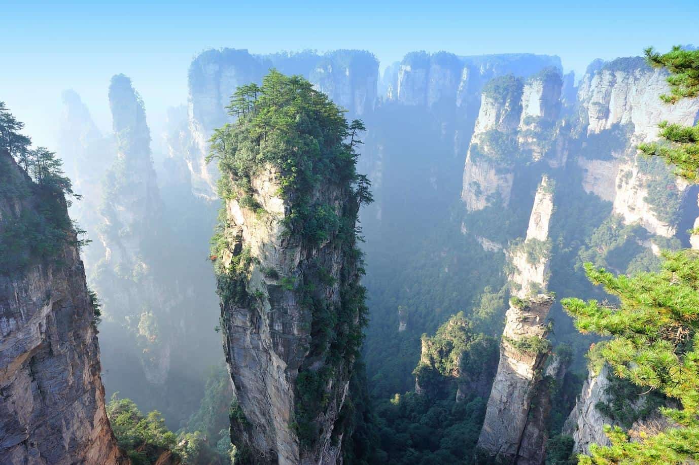
China Has Floating Mountains
Tianzi Mountain in Zhangjiajie, China, is a 22-square-mile area of some of the most unique landscapes on the Earth. It is a collection of natural skyscrapers, some of which are over 4000 feet tall, seem to rise out of the mist. They formed through erosion, but the ancient legends surrounding the place are much more exotic. The tallest of the pillars is called the Kunlun Peak, which has an elevation of 1,262 meters or 4,142 feet tall, and the smallest, which is the Shilanyu, has a height of 534 meters or 1,572 feet tall.
The place is trendy in the area, especially in certain months of the year, mostly when it rains because the mountains tend to get covered in fog that makes any picture look breathtaking. July can be the hottest month of the year, but there are more chances for rain to happen. If you have ever wanted to visit an alien landscape, Tianzi Mountain may be the place to go, as it was the inspiration for the planet Pandora in James Cameron’s movie Avatar. There is even a cable car that runs through the area to view the fantastic scenery with ease.
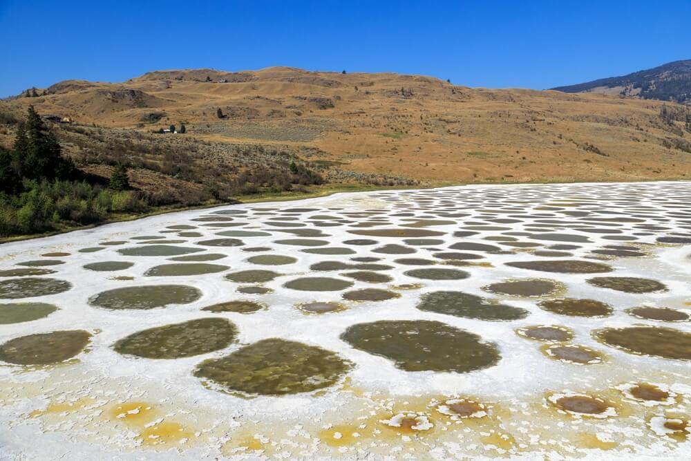
Spotted Lake Has The Same Chemical Make-Up As Mars
Spotted Lake is a lake in the northwest of Osoyoos in British Columbia, Canada. People believe the Earth around Spotted Lake has the same chemical make-up as the soil of ancient Mars. Iit is incredibly salty. In the summer, most of the lake’s water evaporates, which reveals beautiful colorful mineral deposits. Some of the minerals concentrated in the Spotted Lake are Magnesium, calcium, sulfate, and sodium sulfates, plus silver and titanium. Experts theorize that Magnesium sulfate, when it crystallizes, determines the colors and spots formed in the lake.
Formerly known to the First Nations of the Okanagan Valley as Lliluk, the Spotted Lake has remained for centuries as a sacred site because of therapeutic waters believed to have healing properties. The Okanagan Syilx people use minerals in the water for traditional medicine. If you want to visit Spotted Lake and experience for yourself what ancient Mars may have been like, you may have to do so from a distance and respect. Tribal land of the First Nations own the property. They request that visitors do not to trespass and respect the environment around it.
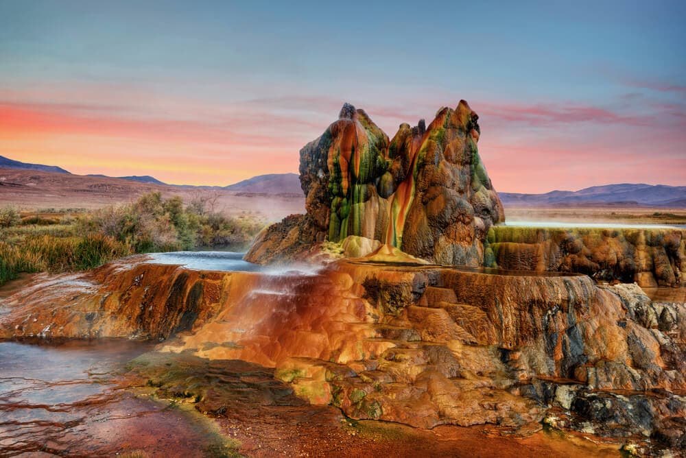
A Geyser In Nevada Is Completely Accidental
In 1964, Nevada’s thermal drilling test went wrong and created a deep fissure in the ground that became known as Fly Geyser. It’s located on the Fly Ranch, a piece of property in the Black Rock Desert. In 1916, people were drilling for irrigation water when a small geyser formed. They abandoned the site when the geothermal water was close to boiling point. Nevertheless, they tried to drill again, and the same thing happened close to the first geyser. That one was not as hot. They used a cap to block the geyser. However, the seal was unsuccessful. As a result, the discharge had so much pressure that it dried the first geyser, making this one much bigger.
The geyser has been erupting pretty much continuously since 1964. It has grown in size because of the high mineral deposits left by the water, which has given the geyser its iconic cones and travertine pools. The cones are about 6 feet or 1.8 meters, and the whole mound is around 25 to 30 feet tall or 7.6 to 9.1 meters. It glows with red and green color because of the iron oxide in the sediments and the algae that are surprisingly well-adapted to the extreme environment.
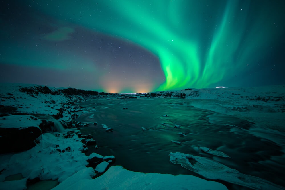
You Can Freeze And Boil At The Same Time In Iceland
Blue Lagoon is a hot spring in Southwestern Iceland that is surrounded by snow. In the winter, temperatures can plunge to well below freezing, leaving people to question whether going for a dip would be a wise thing to do. The spa is near a lava field in front of Mount Þorbjörn on Reykjames Penninsula, an area with much geothermal power that supplies water to a geothermal power station right besides de lagoon. The place is around 12 miles long or 20 kilometers and is considered one of Iceland’s main attractions.
Even if it looks like something mother natured might have made, this lagoon is entirely human-made. Because of the lava field, the water has a lot of mineral concentration, and it can’t be recycled, so every two days, the water is renewed by the plant. The temperature at the Blue Lagoon hot springs remains about 100 degrees Fahrenheit year-round so that visitors can enjoy a warm soak even in the coldest months. The waters stay a light blue because of the mineral content, and the salts in the water are great for the skin. So you can freeze, boil, and get a spa treatment, all in one place.
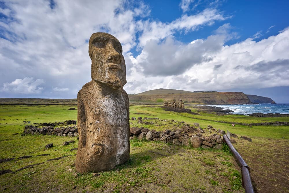
The Moai of Easter Island Have Bodies Under The Sand
Ever since its discovery, Easter Island, which lies some 2000 miles off Chile’s coast, has been known for the massive heads, known as moai, which cover the surface. There are nearly 900 of these statues, and researchers have found that many have bodies underground. Many researchers now believe that Easter Island used to be a lush, forested landscape. However, the inhabitants destroyed its ecological systems by creating and transporting the moai. The moai were an essential part of the people’s mythology and how they practiced their religion.
Experts believe they were carved between the years 1250 and 1500 and transported from Rano Raraku. In fact, most of them are still there, to stone platforms called “ahu.” Someone placed them around the perimeter of the island. It is impressive knowing how technology wasn’t advance in this area. The tallest Moai erected called “Paro” is 33 feet tall or 10 meters and weighs over 80 tons. The heaviest one of the statues weighs 84 tons! There’s evidence that they were more statues, but sadly were destroyed in the early 19th century, possibly during a tribal war.

A Bioluminescent Bay In Puerto Rico Glows Like Stars
In Puerto Rico’s Isla de Vieques’ southern shore, Puerto Mosquito is filled with bioluminescent plankton that glows in the dark thanks to a delicate chemical reaction inside the organism. It has long been on the must-see list of travelers who visit the islands of Puerto Rico. There are only 5 Bio Bays globally, and 3 of them are in Puerto Rico, including Puerto Mosquito, La Pargera, and Laguna Grande. In 2008, the Guinness Book of World Records voted Puerto Mosquito as the brightest bay in the world. Its bioluminescent qualities are already brilliant all year round.
However, in September of 2017, following the devastation of Hurricane Maria, the bay went dark. People thought that its lights might have gone out for good, but the bay recovered to become even brighter than before. Everyone who visits Puerto Mosquito agrees that it is indeed a magical place and a once-in-a-lifetime experience. It is best to experience the phenomenon during a “new moon” phase to enjoy the lights to their maximum strength. So make sure to check the moon phase calendar to find the perfect night to visit.
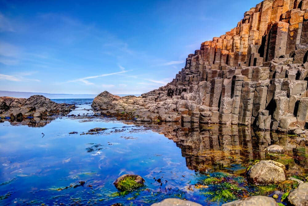
An Ancient Volcano Eruption Left Behind 37,000 Perfect Geometrical Formations
The Giant’s Causeway is a site in Northern Ireland. A massive volcano erupted about 60 million years ago. In turn, the disaster formed the site. The volcano spewed out molten basalt, which contracted as it cooled down and developed into the perfect polygons known as the Giant’s Causeway. There are over 40,000 basalt columns interlocking with each other making this massive and almost unreal area. It almost feels like it’s part of an old video game for texturing rocks. UNESCO declared the Causeway the fourth greatest natural wonder in the United Kingdom in 1986.
Local legends say that a giant created the place, and if you were to visit the site, you would have no problem understanding why. It’s almost like it was taken out from Lord of the Rings. The World Heritage Site comprises 37,000 polygonal columns, which seem to have been laid down with precision. Experts believe that all the contraction after the rock cooled down helped to make those perfect columns into what they are today. However, legends and folklore aside, this place is a must-see if you’re into exploring places that feel like they don’t belong on this Earth.
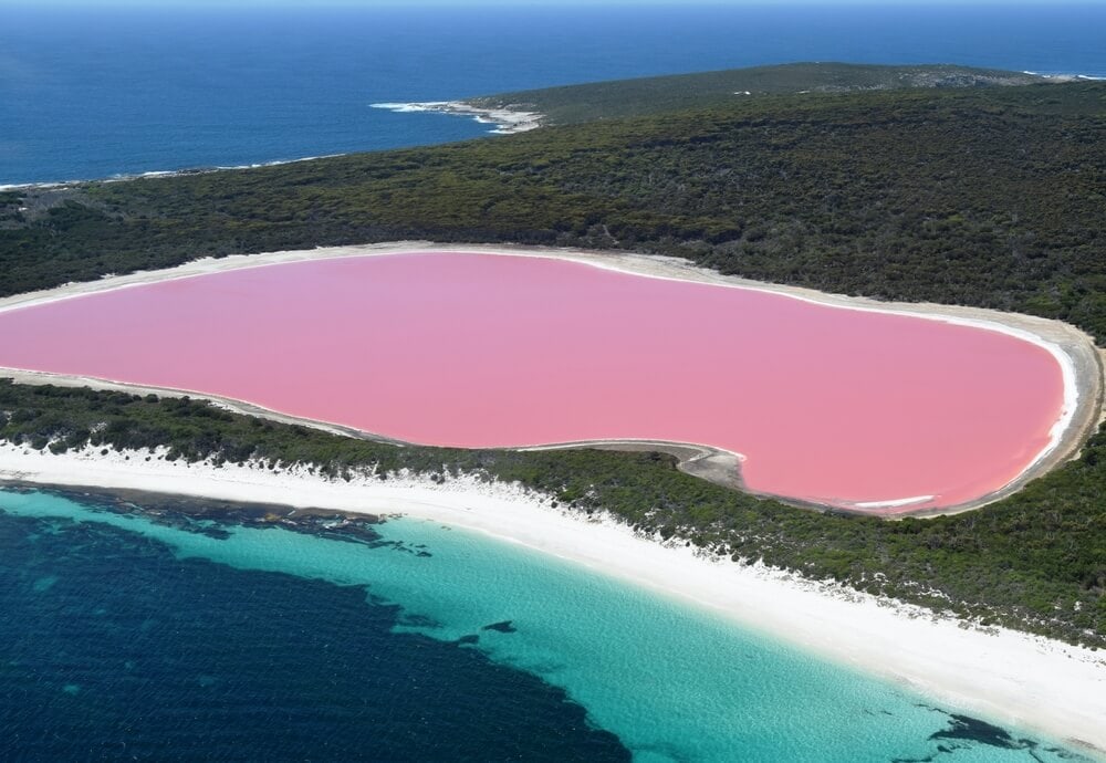
One Lake In Australia Is A Deep Pink
People know about Lake Hillier, which is in Western Australia’s Recherche Archipelago Nature Reserve, because of its deep pink color. The Lake has a high saline content, as well as a type of bacteria known as halobacteria and algae known as Dunaliella salina. Combined, these three factors give the waters their characteristic hue. The lake is about 2,000 feet or 600 meters in length and 820 feet or 250 meters in width. A paperbark and eucalyptus forest create a dense barrier around the lake with a rim of sand to complement it with the pink water.
European explorers discovered the Lake in 1802. The only living organisms that live in the water are microorganisms. Besides that, no fish or plants is habituating the pink waters of the lake. It is somewhat isolated and remote, so there are only a few ways for visitors to get to it. Even though it has a questionable color and a saline content comparable to the Dead Sea, the Lake is safe to swim in. However, it is protected by the Western Australia Department of Environment Conservation, so you’ll need a permit to do so.
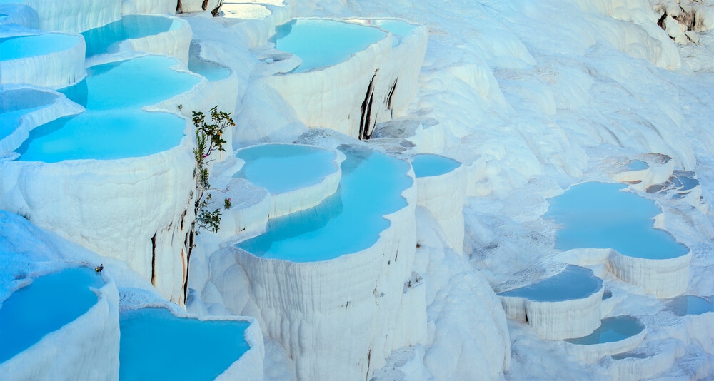
Turkey Has Mineral Springs Made of Limestone
Pamukkale is a place in western Turkey, and its name means “cotton castle.” It was the site of the ancient Greek city of Hierapolis or the Holy City, and one visit will make you realize why it was so revered. The place is made of white limestone, and the minerals in the hot springs have long been known to rejuvenate weary people. Experts believe the Greco-Roman city of Hierapolis was built in the 2nd century BC on top of the travertine. The formation is almost 9,000 feet long, 1,970 feet wide, and 525 feet high.
In addition to being a natural wonder, Pamukkale is an archeologist’s and history buff’s dream. It is the site of many ancient Greek and Roman ruins. They are remarkably well-preserved, possibly due to the hot springs’ minerals. People named it the “Cotton Castle” due to its snow-white limestone dripping down the mountainside. The shimmer makes it look like it is from a fairy tale book. Some legends even say that the formations are solidified cotton that giants left out to dry. Visitors can enjoy artificial pools, enter preserved Roman ruins, and learn more about its history in the museum on-site.
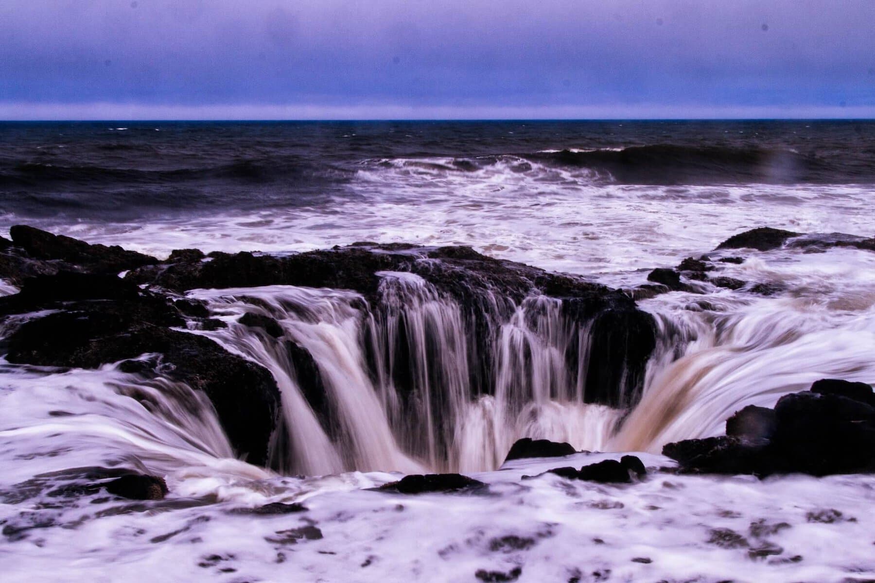
Thor’s Well Absorbs the Tide Before Spewing It Back Out
Thor’s Well is a site off the coast of Oregon that is part of the Captain Cook Trail. It is a natural hole in the ground. Experts estimate it to be about 20 feet deep, but this number can vary depending on the tides; when the tide comes in, the water cascades into the hole until it eventually overflows. Even if some people call it “bottomless,” the sinkhole has a bottom, and falling into it can be extremely dangerous. When it floods, the hole spits the water out up to 20 feet in the air before the water surrounding returns back into the hole. The cycle then repeats.
According to some researchers, the well started as a sea cave made by the crashing of waves that eventually collapsed and created the opening we see today. Experts believe it is around 20 feet deep to make the splash it does when it’s the most active. Thor’s Well is most active during the winter months, during high tide, and during storms. If you visit, please stay on the trail. The site can be quite dangerous, especially on stormy days, because the sudden torrents can sweep anyone right into the maelstrom.
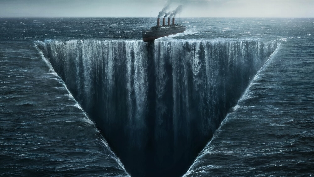
The Bermuda Triangle May Be A Real Thing
The Bermuda Triangle is a 500,000-square-mile swath of land in the Atlantic Ocean. Its three points are Miami, the island of Bimini, and the Bahamas. Also known as the Devil’s Triangle, the area has long been known to cause strange equipment malfunction and swallow entire vessels leaving no trace. Many legends, including U.S. Navy bombers, became disoriented while flying over the ample area or boats vanishing in thin air on a good weather day with no distress signals. These stories are widespread to hear around, but are they real?
While the United States Coast Guard and mainstream scientists dismiss any notion that the area is different from any other part of the ocean, many eyewitnesses claim that mysterious things happen in these waters. Theories range from electromagnetic fields that generate magnetic fog and electric clouds to aliens. Nowadays, all sorts of planes and ships pass thru the area with no incident or anything weird happening. Some scientific explanations have been confirmed over the years, but still, it is more fun to believe that there are some aliens in there than learning about weather conditions.
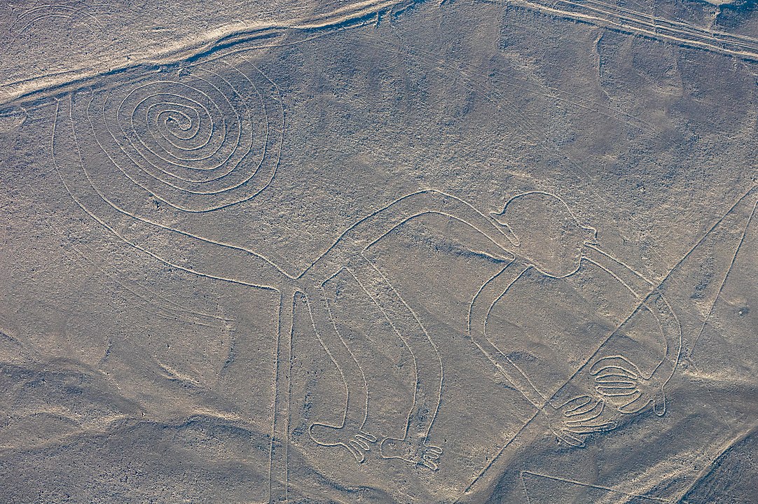
There Are Giant Carvings of Animals In Peru
People know about the Nazca lines. They crisscross the Peruvian pampas, flat and fertile lowlands in South America. What was not realized until aerial photographs were taken was that the lines were not random collections of depressions drawn into the ground. They were massive carvings of animals, some of which were over half a mile in size. Their enormity leads many researchers to question what caused the people of ancient Peru to invest so much time and energy in carving these hieroglyphs and how they could do so with such stunning precision.
Some local theories range from religious significance to slave labor to alien intervention. Nevertheless, scientists believe these large hieroglyphs came to be between 500 BCE and 500 CE. They made shallow and sometimes deep incisions in the desert floor to expose the colored dirt underneath. The combination of all the lines is over 1,300 kilometers or 800 miles, covering an area of 50 square kilometers or 19 square miles, and most lines are over one-third meter or a foot wide. If they are impressive looking at them from a plane, it’s, even more, looking up close on how they made it.

One Hot Spring Site In Iran Is Red
Badab-e Surt is a site in the Mazandaran Province in northern Iran that boasts a collection of hot springs infused with minerals, especially calcium and iron. The site is a collection of stepped terraces of travertine, a type of limestone, which is common to hot springs. What sets Badab-e Surt apart is that the travertine is red. There are two different types of springs in this area; the first one contains very salty water in small pools. People consider the location to have medicinal properties like curing rheumatism and skin diseases.
The second spring is more orange rather than red. The water has a sour taste and high levels of iron oxide or rust in the springs. As a result, the site seems to glow like fire. However, the pyric appearance doesn’t fail to draw visitors. Experts have known about Badab-e Surt since antiquity for its medicinal, healing qualities. In turn, tourists are attracted to rejuvenate themselves in its waters. Others just admire the natural beauty of the place surrounded by a pine forest, making it almost a hidden gem.
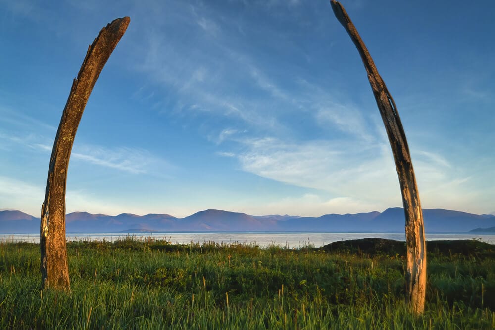
Whale Bones Cover An Island In Siberia
Eighty-two miles off the coast of Alaska lies Yttygran Island, part of the Russian province of Siberia. Massive whale jawbones dot the snowy landscape. They are stuck into the ground to stand upright. All together, they form an eerie, macabre corridor for brave, stalwart tourists to travel. The Whalebone Alley not only has thousands of bones and stones, but it also has a large number of meat storage pits that were used by different villagers, making this place a central shrine between all of them. However, there is no evidence of any rituals happening in the area.
The site likely dates to about the fifteenth century and may carry religious significance. Although the local Yupik people have a more straightforward explanation that all the bones there are, it is a collective center for butchery, flensing, and overall the hunter’s favorite place to process their meats. The area extends around 1800 feet or 548 meters along the northern coast of Yttygran island, covering a few strategic areas for the locals in the area. However, the exact purpose of the site remained unknown. You can visit the area and find out for yourself.
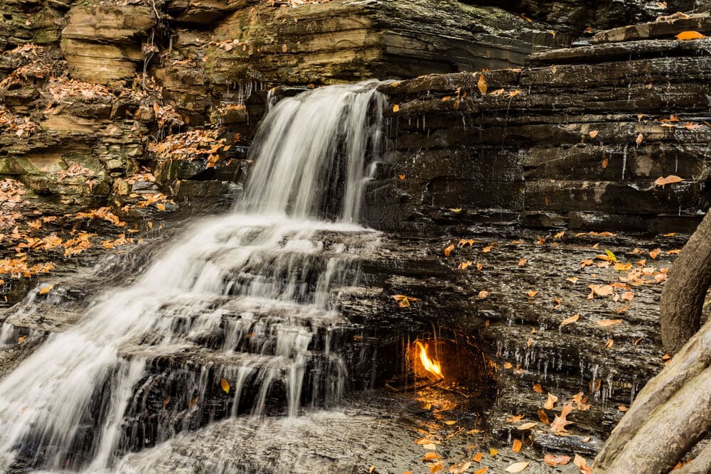
A Fire Burns Under A New York Waterfall
Eternal Flame Falls is a majestic, breathtaking waterfall in upstate New York. It is part of the Shale Creek Preserve in Chestnut Ridge Park. However, visitors to this cataract often get more than they bargained for because, in addition to flowing with water, the place burns with fire. A natural gas reservoir lies under a spot inside the waterfall, so there is a flame that burns perpetually. Hence the name “Eternal Flame Falls.” This part of the preserve was mostly unknown until it was featured in the book Secret Places by Bruce Kershner and gained popularity.
Various geologists from the States and Europe have come to investigate the Eternal Flame to understand better how natural gas emitted hydrocarbon seeps to add to the greenhouse gases in the atmosphere. They concluded that the “macro seep” in the eternal flame falls has a higher concentration of ethane and propane than any other known natural gas seeps. They also found that it emits approximately one kilogram or 2.2 pounds of methane a day. Interestingly enough, the fire can be extinguished, and other times it destroys itself with the water, and caretakers occasionally put it out and then relight it.
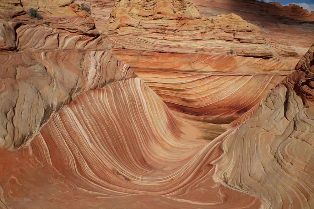
Riding the Waves of the Canyon in Arizona
In the Coyote Buttes ravine in Arizona, over 5,000 feet above sea level, you can find what is called simply: The Wave. It comprises Navajo sandstone dunes that have calcified vertically and sometimes horizontally that, when hardened, compacted the rocks over time. Wind and rain erosion created the structure’s beautiful orange color with its dramatic lines. The slow process took over 190 million years ago. People consider the amazing location one of the world’s greatest geological formations. What’s interesting is that people did not know about the Wave until recently, around the 1990s!
This beautiful place was made aware thanks to a German travel brochure that advertised it. In 1996, it was shown in the German film” Faszination Natur” and became a favorite place to visit European tourists. Every year, thousands of tourists visit the trippy dunes, which people have described as a surreal experience that may cause vertigo if you stare too much at it. Some say it’s like being in a waking dream. Today, this place is very popular with photographers. However, it is essential to know that only 20 visitors a day are allowed to walk through the area due to being susceptible to damage.
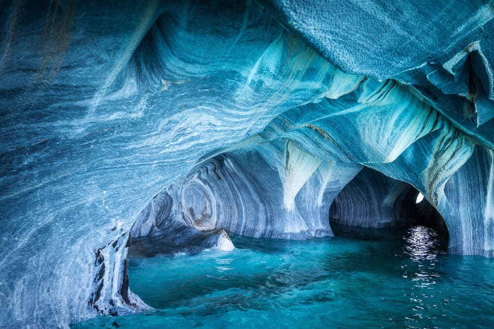
The Hidden Marble Caves
These caves are located at the glacial Lake General Carrera on the border between Chile and Argentina. It is believed they were formed from 6,000 years of waves crashing into the calcium carbonate, creating the glossy surface with the swirly blues that are smooth reflections of the water underneath. The colors tend to change of intensity depending on the water levels too. It is a breathtaking view that you wouldn’t think about seeing when visiting the small rock in the middle of a lake. If you want to visit, there are a few things that you need to know to prepare for your trip.
The only way you can make it to the cave is by boat, and there is a local company that provides a 30-minute tour of the cave, that is, if there are perfect weather conditions to make it because if the tide is too hide, the cave is inaccessible. The ideal time of the year to visit the Marble cave is around September and February when the ice of the area and the Andes melts. It feeds it to the lake and what you get is a boost of enchanting turquoise inside the cave that is great for the perfect photograph.
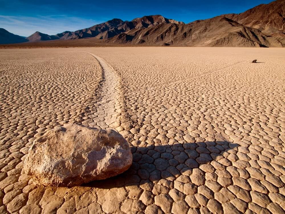
The Mysterious Case of the Sailing Stones
Death Valley National Park, located on the border between Nevada and California, is one strange and exciting place to visit if you’re into trying to solve some mind-blown mysteries. It is considered the hottest place on Earth and also the driest and lowest elevation in North America. Inside the park, there is a place called the Racetrack Playa and one can say that it is one mysterious place! It is the home of rocks that drift across the flat desert landscape, propelled by no power other than their own hard surfaces! It is a head-scratcher with an interesting explanation.
Even if no one has seen the rocks moving across the area, researchers have found that it has to have the “perfect storm” of conditions. The stones are mostly three types: syenite, dolomite, and black dolomite. Depending on the bottom’s roughness, the trails tend to be different; if it’s smooth, they tend to wander, and if they are rough, they leave straight tracks. However, they also need to have a flooded surface. It’s better if their warming temperatures can cause ice breakup and thin layers of clay, and lots of wind. They move extremely slow, so you’ll need an excellent steady cam and patience to see footage of them moving during the day.
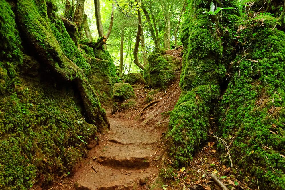
An Enchanting Yet Puzzling Forest
Here is a forest for a fantasy book. You probably envision fairies and fauns. You can visit this amazing place on Earth in Coleford, England. Puzzlewood is one magical place that will make your imagination wander across moss-covered rocks, bridges, and beautiful pathways. You might even recognize it from shows like Doctor Who and Merlin! People consider the 14 acres of dense forest a great example of an open cast iron mine in the Pre-Roman Celtic era. The forest owner probably constructed the rustic paths and bridges were probably constructed in the early 19th century. This area was in hiding for 100 years until it became open to the public.
J.R.R. Tolkien’s The Lord of the Rings was inspired by this unique location. It shows; the forest of Dean feels like you’re walking in Mirkwood or the Old Forest in Middle Earth. There are areas where it shows evidence of the Romans occupying the forest, like over 3,000 coins from the Third Century being found hidden between trees and human-made structures that are believed to were used for mining. Today, the place is ready to welcome visitors, with picnic areas, gift shops, and even a working farm with donkeys, rabbits, goats, and cattle.
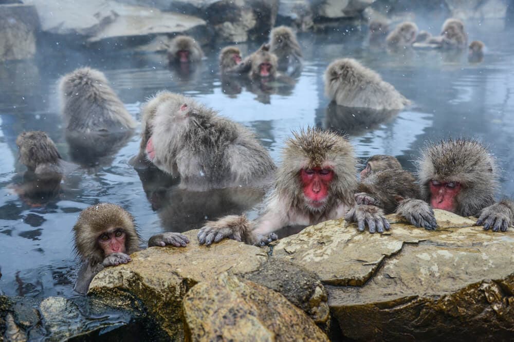
A Spa for Monkeys
The harsh snowy, frigid weather of Jigokudani could make anyone run for cover if it wasn’t for its calming hot springs. Jigokudani, which translates to “Hell’s Valley,” is a park in Yamanouchi, Japan, with stunning jagged cliffs over 2,500 feet into the air. It is the home for a large population of Japanese Macaques, also knowns as Snow Monkeys. In the early 1960s, the story goes that a group of snow monkeys decided to try out the waters of the natural hot spring to warm up, and they never went back to the forest.
The hot springs can go above 122 degrees Fahrenheit, which is perfect for the freezing environment, and it sits well not only for the snow monkeys but also for humans. Even if this is not a religious site, there are many fables in Japanese folklore where they believed that Snow Monkeys are messengers of the Shinto mountain gods and rivers. The park is open all year round, but it is best to experience this in the winter and to arrive early so you can even feed the monkeys and go for a spa day with them. Just remember to bring your snow boots and jackets!
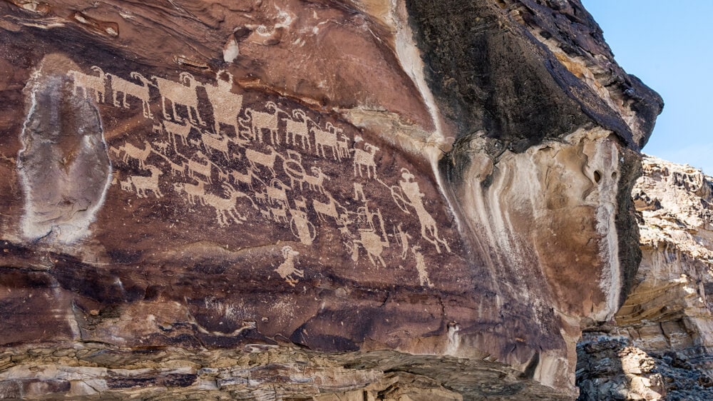
World’s Longest Art Gallery
One hundred twenty-five miles from Salt Lake City, Utah, deep in the desert lies an art exhibition over a thousand years old. Ancient native people, the Fremont, carved these petroglyphs and pictographs directly into the canyons. The Nine Mile Canyon is way longer; it’s 40 miles! No one knows precisely where the name comes from. However, locals think it was the explorer John Wesley Powell; he used a nine-mile transect to map the area. The world’s longest art gallery contains the history of the natives in the area in a stunning rocky road.
The intricate images go from the Fremont era, which is around 400 CE to 1400 CE, to later Native Americans (mostly from the Ute nation) and western settlers and explorers during the 19th century. Most carvings depict hunting scenes and animal life of birds, lizards, and bison that are very easy to identify. There are also the remains of an old town called Harper around halfway thru the canyon that is now a ghost town. The Antiquities Act protects the location. So even if you can visit, it is imperative to leave everything as it is so that generations can admire this ancient art gallery.
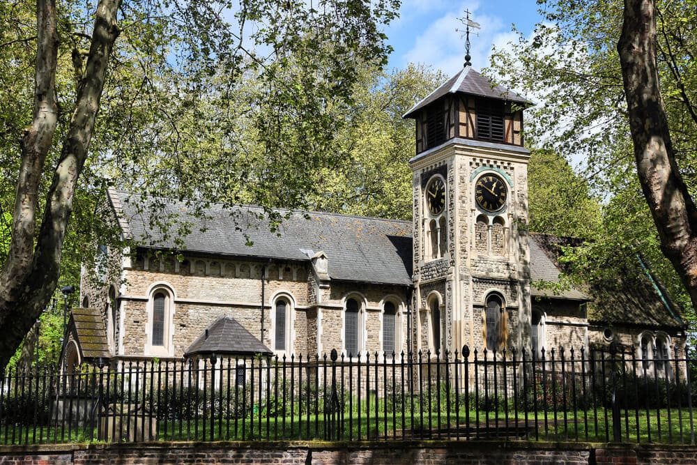
Where Gravestones Lay to Rest
Hidden inside an ancient London Churchyard, there is an ash tree with too many gravestones around it and a so odd story that it is a must-see place on our list. St. Pancras Old Church is England’s oldest church, and right alongside is a cemetery that is just fascinating. It is where author Mary Shelly and Percy Bysshe Shelley planned their wedding while visiting her mother’s grave. However, most importantly, classic novelist Thomas Hardy surrounded an ash tree with hundreds of weathered gravestones, mostly layered on top of each other. But why?
With Britain’s growth and expansion to accommodate its population, it left little space for St. Pancras’ graveyard to be it. So an architecture firm was hired to exhume its residents’ remains and rebury them at another place. So the firm put their youngest employee for the task, and it was none other than Thomas Hardy, the author of the novel Far from the Madding Crowd. After moving all the bodies, he took the remaining headstones and placed them in a circular pattern around the ash tree named the “Hardy Tree.” You can still check the place’s remains since the tree has absorbed many of the headstones, leaving a very creepy scene.
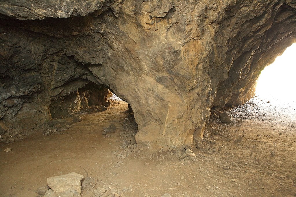
Visit the Batcave
One of the comic book’s most iconic superheroes has left a mark on his fan’s hearts, but also in nature. Bronson’s cave location is in Griffith Park in Los Angeles, California. Did you enjoy watching the 1960s Batman TV show? You might recognize it as the entrance to the Batcave. This park has been set to many films and TV shows because of how versatile the park’s scenery is, with different climates and landscapes that can make any film pop. Nevertheless, if standing inside the Dark Knight’s hidden lair is on your bucket list, then you are in luck.
When you enter the cavern’s mouth, you realize that it is not a cave but a short tunnel. With the magic of filmmaking, viewers can see an epic cave filled with many gadgets. Other movies and tv shows, mostly sci-fi, have also used this place. The location is always open to the public, so you’re in the area looking for a neat place to visit to feed your inner child or even to film your low-budget film, this is the perfect place to go.
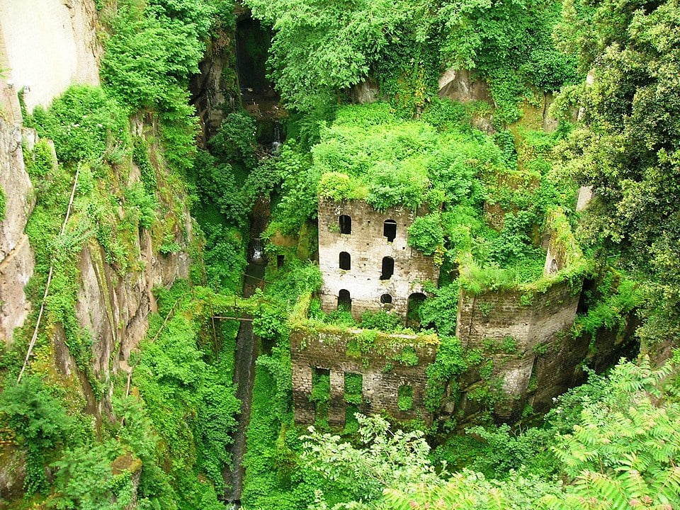
When Nature Devours Buildings
The Valley of Mills or “Valle dei Mulini” are hidden ruins of what is was once flour mills. The site is located at the bottom of a deep crevasse in Sorrento, Italy. A massive eruption once hit the building. It devastated the area around 35,000 years ago. The stone buildings were once flour mills built around the 13th century. They used the stream at the bottom of the valley for energy to keep the mill going. It was essential for grounding all types of wheat that the people close by needed.
Nevertheless, after hundreds of years, times have changed. The mill had to be closed and abandoned in the 1940s, leaving the gorgeous buildings to the environment. Overtime, the sides become covered with greenery. Equally, the site became the house of many forest critters. However, In 2019 the city of Sorrento voted to restore the mills. That way, it would make them more accessible to visitors and less dangerous. You can still view the haunting buildings from Viale Enrico Caruso, a suspended hotel over the canyon. However, you can always get up close and enter the mills.
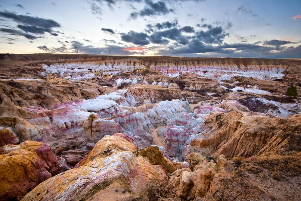
The Best Clay for Pottery
The weird-looking and colorful geological formations in the Paint Mines Interpretive Park are amazing. They consider the site a geological wonder of El Paso County’s eastern plains in Calhan, Colorado. The beautiful sand and clay that is bursting with color. It mesmerized Ancient Native Americans over 9,000 years ago, making it their favorite place to collect clay. In turn, they used this clay to make their colorful pottery. They would also use it as war paint on their bodies and war-horses as a way of protection from the upcoming battle. Water, wind, and erosion formed the hoodoos and sandstones. They also affect the coloring.
The park has 4 miles or 6.4 kilometers of trails in 750 acres of beautiful scenery and grasslands, perfect for anyone looking to explore the area. The area is a protected site by law because the formations are fragile, especially with the natural animal and plant ecosystem that lives there. There is also much archaeological significance because of all the artifacts found on the site. It is an excellent place for hikers and birdwatchers. Camping and motorized vehicles are not permitted. It is also essential to stay on the trail and off the sandstone formations.
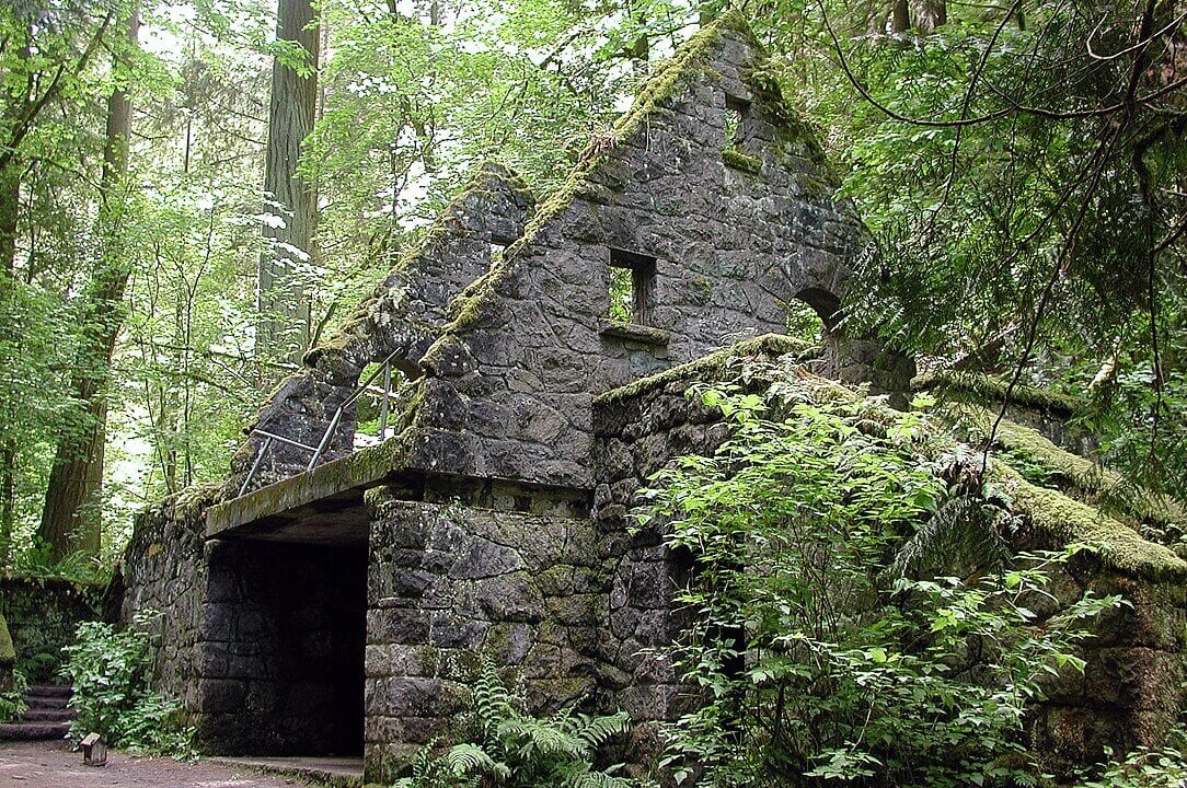
A Witch Castle that Is Not Hocus Pocus
This old building in Portland, Oregon, has passed thru a lot of not very pleasant things since it was built. You can even call it haunted by the ghost of the past. A cursed witch might even have lived in this house. Before the building even existed, a man named Danford Balch owned the building in the 1800s. He lived with his family of 10. When one of his daughters fell in love with a grounds caretaker named Mortimer Stump, Balch threatens to kill him if he eloped with her. Well, they wed, and after they returned, Balch killed Stump. In turn, the town executed Balch in 1859.
A few different hands exchanged the property until it was bequeathed to the city’s Parks and Recreation Department. They added a park ranger station and restroom for hikers in the 1930s within the location. In 1962, a storm damaged the building. Nobody claimed the abandoned property until the 1980s. Then, a group of kids found it and used it to hold parties. The student named it the Witch’s Castle. Today, you can visit the “Castle,” but it’s a difficult half-mile hike to get there, but the creepy-looking place is all worth it, especially for a night of ghost stories with your friends.
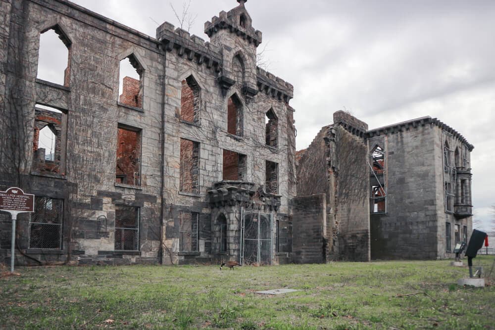
The Ruins of a Smallpox Hospital
Human history is filled with diseases since the beginning of time. However, one that greatly impacted human civilization, besides the one we are living in now, was because of smallpox. Before a vaccine was discovered in the late 1700s, around 400,000 people died every year in Europe. It was eradicated in 1979. However, before that happened, cities built hospitals just for treating smallpox. So when New York City needed to find a place for this hospital, they went with Blackwell’s Island (now Roosevelt Island) since they could keep the infected patients away from the population.
The Gothic style smallpox hospital named Renwick Hospital treated around 7,000 patients a year from 1856 until 1875. They turned it into a nurse’s dormitories when authorities moved the hospital to another area. After they completed everything, though, the city abandoned the building. The Landmarks Preservation Commission took interest in the property. They declared the site a city landmark, even though it was nothing but ruins. They reinforced the walls to prevent it from collapsing. However, they never fully renovated the building or opened it for tours. Nevertheless, you can still see what’s left of it behind a fence. Feel free to admire what was once a place to feel better.
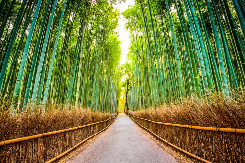
The Relaxing Sounds of the Bamboo Forest
The Sagano Bamboo Forest’s calming nature in Kyoto, Japan, is an escape from the busy city life. The location is only 30 minutes from Kyoto City Center. The breathtaking bamboo trees are a big contrast from the urban vibe close by. It is a very popular place for tourists to gather. That means lots of camera shutters and chattering. Nevertheless, walking its pathways and concentrating on the extremely tall stalks is worth it checking out. The sounds of the creaking, rustling, and swaying the bamboo make are iconic. So much that the Ministry of the Environment considers it a part of Japan’s soundscape. The weather in the region is a very sunny, humid, and relatively cool climate most of the year, making it great for bamboo to grow. It is also a trendy place to meditate when there are not too many people making noise.
It is also a diverse ecosystem, with animals like Giant Pandas and Mountain Gorillas, bats, and various birds like antbirds, drysophila, and flatbill, being the most common sharing the space. That is a very diverse ecosystem. Common animals seen in this region are the giant panda, mountain gorilla, and tiny bat. Common birds here are drymophila, flatbill, and antbird. Bamboo is the dominant plant in this forest and proliferates. It grows 36 inches in 24 hours. However, it depends on a unique rhizome-dependent system. Bamboo is pollinated by the birds and some animals that live in this forest. In return, bamboo has become a staple diet for the Pandas and a home for the tiny bat and other small animals, as well as an individual ecosystem.
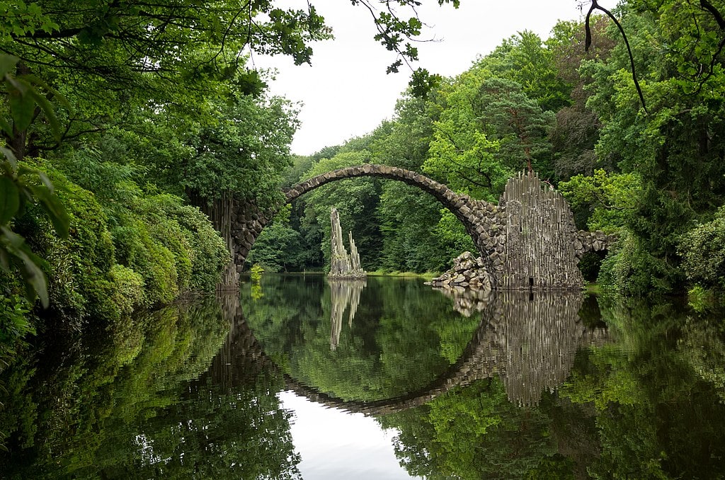
The Devil’s Bridge
This unique place features Kromlauer Park’s foliage in Kromlau, Germany. An even more surprising sight to see is a delicately-arched Devil’s Bridge (aka the Rakotzbrücke). Experts build these types of bridges to create a full circle in the water reflection. The name also comes because they look so dangerous that Satan himself might be the creator of them. There are many types worldwide, but this one takes the cake for the thin arch and fantasy-like form it has. A local knight commissioned it in 1860. He wanted it decorated with slender rock spires around an English-style garden.
Although this human-made bridge is aesthetically beautiful to look at, they are not too safe, so in that regard, they are not practical to use. However, the fantastic look it gives to the park is perfect for photography enthusiast to come and see. However, because of its age and how fragile this type of bridge is, people cannot cross it. We recommend visiting the place around the fall when the foliage brings a magical effect to the atmosphere. You should also cross your fingers that the waters are still and with enough sun to see the illusion of the perfect circle it creates with the water.
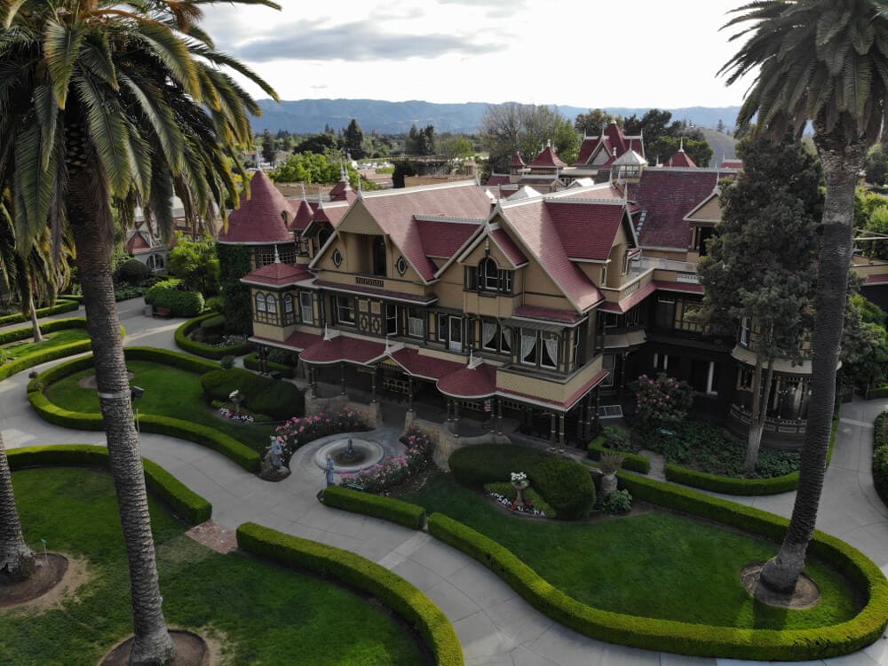
A Mansion With Doors That Go Nowhere
When it comes to strange places, this one takes the cake. The Winchester Mystery House in San Jose, California, will leave you scratching your head. A very eccentric woman named Sarah Winchester moved to San Jose from New Haven, Connecticut. She bought a small eight-room farmhouse in 1886, and slowly started renovating the place. However, she kept working on it for 36 years, spending $5.5 million in the money of the time. The tireless woman passed away in 1922. Only then did she stop working on renovation, which is a valid excuse.
The finished house was a thing to behold. It has indoor plumbing (something rare to see at the time), multiple elevators, and central heating. In total, it has over 160 rooms, 40 bedrooms, 10,000 windows, and two basements. If you think that’s insane, wait until you hear about the 2,000 doors. You can’t walk through some of them. There is one that leads to an 8-foot drop to a kitchen sink. No one knows why Mrs. Winchester wanted to keep renovating. However, people think she was being haunted by the people killed by her husband’s invention: the Winchester rifle.
Where Did We Find This Stuff? Here Are Our Sources:
“Thor’s Well.” 10 Random Facts.
“Pamukkale.” Wikipedia.
“20 Seriously Weird Places Around the World.” Rough Guides. May 17, 2019.
“The Strangest Places On Earth,” by Eric Vega. Ranker.
“These 19 Nightmarish Places Will Keep You Awake At Night… They Sent Chills Down My Spine.” ViralNova.
“A 2019 Compilation Of 50 Weirdest Places Across The World You Should Stop By.” Travel Triangle.

